


Leroy Fire House, Washington County, Alabama
About
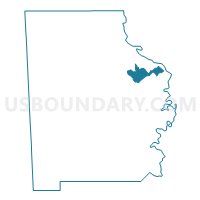
Outline

Summary
| Unique Area Identifier | 523093 |
| Name | Leroy Fire House |
| County | Washington County |
| State | Alabama |
| Area (square miles) | 12.22 |
| Land Area (square miles) | 12.19 |
| Water Area (square miles) | 0.04 |
| % of Land Area | 99.71 |
| % of Water Area | 0.29 |
| Latitude of the Internal Point | 31.49525350 |
| Longtitude of the Internal Point | -88.00834990 |
Maps


Graphs
Select a template below for downloading or customizing gragh for Leroy Fire House, Washington County, Alabama


Neighbors
Neighoring Voting District (by Name) Neighboring Voting District on the Map
- Carson/Preswick, Washington County, AL
- Cortelyou, Washington County, AL
- Hobson Fire House Voting District, Washington County, AL
- St. Stephens Fire House, Washington County, AL
- Wagarville Fire House, Washington County, AL